Richland County, Ohio USGenWeb Site

Plat Book, 1873

Mifflin Twp.

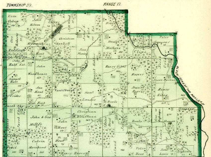
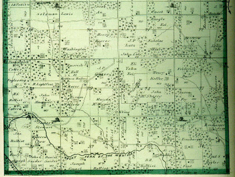
Township 23 / Range 17

Source:  ATLAS MAP OF RICHLAND COUNTY, OHIO.  Compiled, Drawn & Published from Personal Graminations & Surveys by A.T. Andreas.  Chicago, Ill., 1873, p. 37.

Select Other Township Maps  |  Legend of Symbols Used


Click on twp. map to see how the sections of this township are arranged


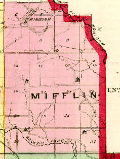
MIFFLIN TOWNSHIP, was organized September 5th., 1814.  It was, previous to that, a part of Vermillion, which was one of the four original voting precincts of the County.  It was, at first, eighteen miles in length, by six miles in breadth.  Mr. Jay Smiley, and his brother David came there in 1817, and worked for Mr. William and George Reynolds, who lived half a mile south of the present town of Windsor.  The first elections were held when the township was a part of Vermillion, in 1813-14.  The Black Fork of the Mohican forms a boundary on a portion of the north and northeast, and the Rocky Fork flows through the southeastern portion, so that the township is furnished with abundant water and mill privileges.  The population of the township in 1870 was 901.

** see also:  List of some Mifflin Twp. Residents


Section Maps

(click on an image to view at actual size)

North Section

South Section


Farm Index for this Township

Surname Name Section
Aby Isaac 22
Amsbaugh Henry 31
Au Jacob 20
B. P. 6
B. W. 33
Backer A.B. 22
Balliet H.S. 30
Balliet J. 33
Balliet Jno. 31
Balliet S. 33
Balliet Solomon 32
Balliet Wm. 32
Balliett D.H. 33
Ballyet Jacob 15
Barr Frederick 27
Bell Emerick 29
Bell Rebecca 29
Bell W. 29
Boals D. 9
Boals J.W. 16
Boals Josiah 16
Boals Josiah 9
Brindle J. 4
C. E. 8
Chew Rebecca 31
Cline L. 4
Cole B. 17
Cole John 21
Cotter Wm. 30
Cotter Wm. 5
Cotter Wm. 6
Crider Jacob 10
Crider Jacob 3
Crider T. 7
Daubenspeck ?.S. 30
Eby Jacob 18
Eby Jacob 7
Eighinger Geo. 15
Ernsbarger E.N. Jr. 34
Ernsbarger E.N. Sr. 34
Fleming Jane 5
Fleming Jane 8
Fleming W. McA. 5
Foglesong J. 30
Fry Susan 27
Gates J.P. 29
Gates Wm. 18
Gongwer J. 10
Gongwer J. 15
Gongwer P. 4
Gongwer Peter 3
Griffith Wm. 28
H. S. 17
H. W. 6
Hale J.S. (est.) 6
Hale John S. (est.) 5
Hale John S. (est.) 7
Hale S. 6
Henry Nicholas S. 21
Hilton John 6
Hoover A. 9
Hoover C. 9
Hoover Daniel 9
Hoover Henry 17
Hoover Henry 20
Hostetter J. 22
Hout D. 17
Hout Geo. 7
Hout John 17
Hout Jos. 6
Hout Jos. 7
Hout Peter 16
Hunt Wm. 33
Kauffman Christian 17
Kayler Fred S. 34
Keffer Henry 28
Kling D. 28
Kohler Daniel 5
Kohler Daniel 8
Koogle Jacob (est.) 21
Landis Sam'l. 8
Leiter David 34
Lewis S. 16
Lewis S.S. 22
Lewis Samuel 15
Lewis Solomon 15
Lewis Solomon 19
Lewis Solomon 20
Lightfoot R. 30
Lightner J. 15
Lutz J.P. 21
M. J. 28
Markhart A. 33
Markley D. 27
Mathews Daniel 4
McBride Washington 20
McCormick Wm. 6
McDermot Marcus 29
McSherry John 28
Mentzner John 30
Miller John & Geo. 18
Morehead C. 19
Morehead Calvin 18
Nissley Daniel 19
Nissley Daniel 30
Osbun Ezra 6
Pettit I.B. 18
Pettit J. 18
Pettit Jonathan 19
Pettit T.B. (or I.B.) 19
Portner Jesse 10
Redding P. 6
Roberts Geo. 6
Ross C. 33
Royer Fred 33
Royer Fred 34
Royer W. 29
Simpson Joseph 27
Sites Henry 10
Sites Henry 9
Smart Joseph 32
Snider Daniel 31
Snider John C. 31
Snook J.W. 28
Snyder C. 16
Staman Wm. 15
Stewart James 31
Sunkell Christian 5
Swigart L.M. 28
Swigart L.M. 32
Swoveland Peter 16
Swoveland Peter 21
Vantilburgh John B. 8
W. H. 28
W. H. 32
Walters Hiram 29
Ward J.B. 5
Woodhouse John 7
Yeaman J. 22
Yoha Eli (est.) 28
Zellner W. 33

Farm index was created by Amy E. Armstrong, 12 April 2005


<< Back to 1873 Plat Book Page

View other Land Records >>

<< Back to the Richland Co., Ohio Index