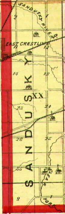
Richland County, Ohio USGenWeb Site |
Plat Book, 1873 |
Sandusky Twp.
Source: ATLAS MAP OF RICHLAND COUNTY, OHIO. Compiled, Drawn & Published from Personal Graminations & Surveys by A.T. Andreas. Chicago, Ill., 1873, p. 68
Select Other Township Maps | Legend of Symbols Used
Click on twp. map to see how the sections of this township are arranged
SANDUSKY TOWNSHIP, About two-thirds of this township is now embraced in Crawford County, but it was originally a part of Springfield Township, and the first settlers were the Welches, Condens, Coffenburys, Dougalls and Finneys. It has but a small population, but unlike some other towns has steadily maintained its standing in point of population, and has increased in wealth. By the census of 1870, the population was 688. Three railroads pass through it, and there are many fine farms devoted to fruit and grain.
** see also: List of some Sandusky Twp. Residents
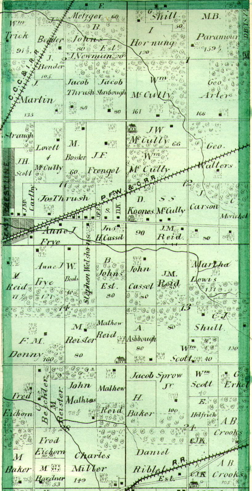
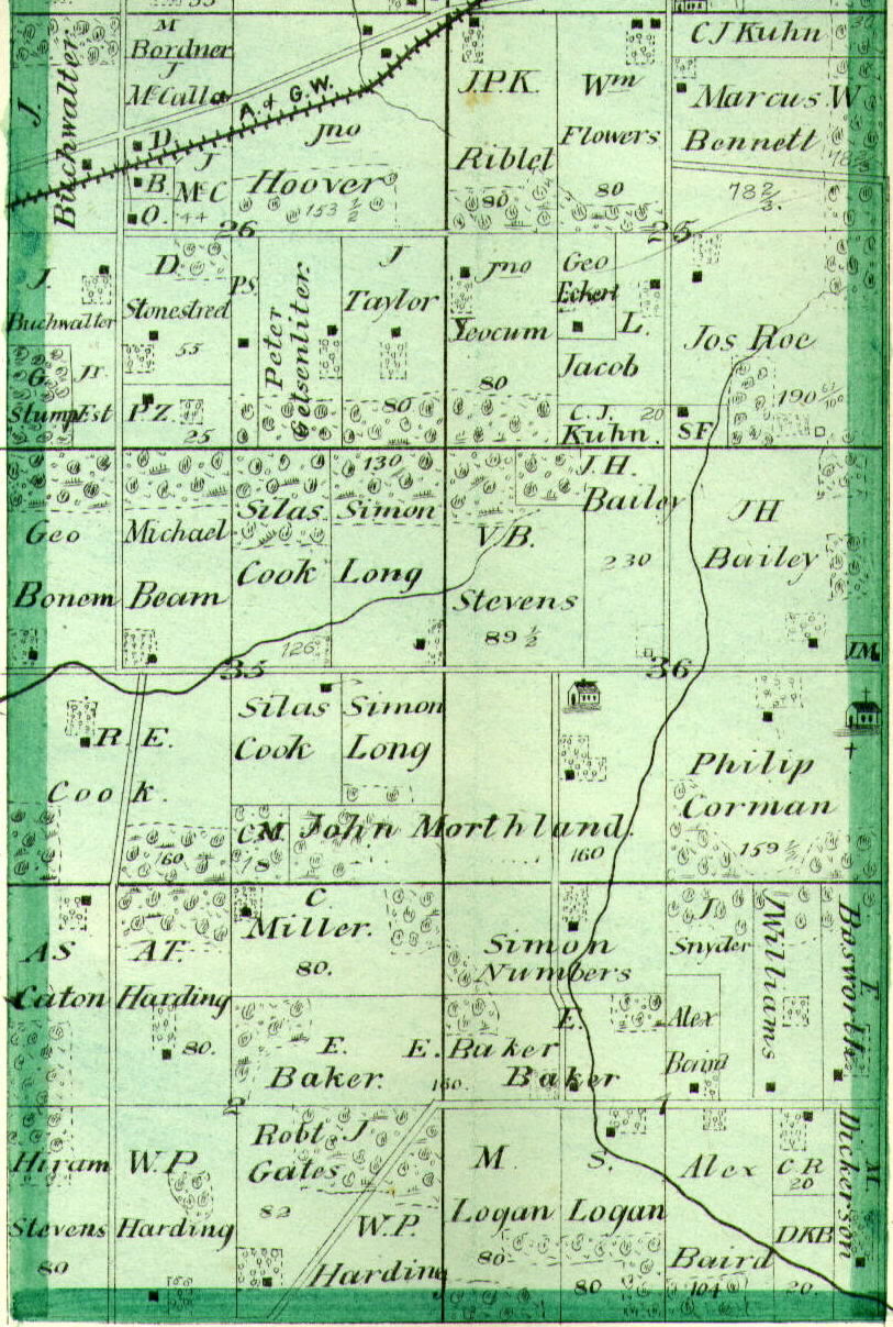
Section Maps
(click on either the top image or the bottom image to view at actual size)
Farm Index for this Township
** Note: Sections 1a and 2a are at the northernmost portion of the map. Section 1b and 2b are at the southernmost portion of the map.
Surname | Name | Section |
---|---|---|
Arter | Geo. | 1a |
Ashbough | A. | 13 |
B. | D. | 1a |
B. | D.K. | 1b |
Bailey | J.H. | 36 |
Baird | Alex | 1b |
Baker | E. | 1b |
Baker | E. | 2b |
Baker | H. | 24 |
Baker | M. | 28 |
Beam | Michael | 33 |
Bender | J. | 2a |
Bennett | Marcus W. | 25 |
Beschler | C. | 28 |
Boals | W. | 14 |
Bonem | Geo. | 33 |
Bordner | M. | 26 |
Bordner | M. | 28 |
Bossler | M. | 11 |
Bosworth | E. | 1b |
Buchwalter | J. | 26 |
Butler | J.H. | 36 |
Cassel | Jno. H. | 11 |
Cassel | John | 13 |
Caton | A.S. | 2b |
Cook | R.E. | 33 |
Cook | Silas | 33 |
Corman | Philip | 36 |
Crooks | A.B. | 24 |
Denny | F.M. | 14 |
Dickerson | M. | 1b |
Eckert | Geo. | 25 |
Eichorn | Fred | 28 |
Erkel | G. | 24 |
F. | J.F. | 11 |
Flowers | Wm. | 25 |
Frengel | J.F. | 11 |
Frye | Anne J. | 11 |
Frye | Anne J. | 14 |
Gates | Robt. J. | 2b |
Getsenliter | Peter | 26 |
Harding | A.T. | 2b |
Helrich | E. | 24 |
Hoover | Jno. | 26 |
Hornung | I. | 1a |
Jacob | L. | 25 |
Johns | B. (est.) | 14 |
Johns | J.B. (est.) | 2a |
K. | D. | 11 |
Koones | D. | 12 |
Kuhn | C.J. | 25 |
Kuhn | C.J. | 25 |
Lewis | Martha | 13 |
Logan | M. | 1b |
Logan | S. | 1b |
Long | Simon | 33 |
M. | C. | 33 |
Mathias | John | 28 |
McC. | J. | 26 |
McCalla | J. | 26 |
McCarthy | J. | 11 |
McCully | J.W. | 12 |
McCully | Lovett | 11 |
McCully | S.S. | 12 |
McCully | Wm. | 12 |
McCully | Wm. | 1a |
Metzger | F. | 2a |
Miller | C. | 2b |
Miller | Charles | 28 |
Morishel | C. | 12 |
Morthland | John | 33 |
Morthland | John | 36 |
Newman | J. (est.) | 2a |
Numbers | Simon | 1b |
Paramour | M.B. | 1a |
R. | C. | 1b |
R. | C.J. | 24 |
Reid | J.M. | 12 |
Reid | J.M. | 13 |
Reid | M. | 14 |
Reid | Mathew | 14 |
Reid | Matthew | 28 |
Reister | M. | 14 |
Reister | M. | 28 |
Riblet | Daniel | 24 |
Riblet | J.P.K. | 25 |
Roe | Jos. | 25 |
S. | - | 11 |
Scott | Wm. | 13 |
Scott | Wm. | 24 |
Shenbough | Jacob | 2a |
Shill | G. | 1a |
Shull | C.J. | 13 |
Snyder | J. | 1b |
Sprow | Jacob Jr. | 24 |
Stevens | Hiram | 2b |
Stevens | V.B. | 36 |
Stonestreet | D. | 26 |
Straugh | - | 11 |
Stump | G. | 26 |
Taylor | J. | 26 |
Thrush | Jos. | 11 |
Trick | Wm. | 2a |
Walters | Geo. | 12 |
Welston | Stephen | 14 |
Williams | J. | 1b |
Yocum | Jno. | 25 |
Farm index was created by Amy E. Armstrong, September 28, 2002
<< Back to 1873 Plat Book Page
View other Land Records >>
<< Back to the Richland Co., Ohio Index